1 km
5000 ft
Leaflet | Tiles © Esri — Esri, DeLorme, NAVTEQ, TomTom, Intermap, iPC, USGS, FAO, NPS, NRCAN, GeoBase, Kadaster NL, Ordnance Survey, Esri Japan, METI, Esri China (Hong Kong), and the GIS User Community

A work in progress to make a simple map based collaborative database of paragliding sites, clubs and pros worldwide.
The data provided on this site is for informational and planning purposes only.
Absolutely no accuracy or completeness guarantee is implied or intended. All information on this website is for informational purpose only and must not be used and trusted 'as is'. Please understand that it may be outdated, unclear, or simply wrong !
We hope you are aware that you can not trust anything you read on the internet: the website owner can not be held responsible for any decision taken on the basis of the information presented here : please always consider getting fresh and official legal information from the flying sites local people, clubs and/or authorities and consider the weather carefully before you go fly !
This beeing said, fly happy and safe ! ;)

This work and your contributions are licensed under Creative Commons Attribution-Share Alike 3.0 Unported License.
Starting December 10th of 2024, new contributions will also be added in a separate database licenced under ODbL 1.0.
Website built with Leaflet, from a bootleaf basis.
A big thank you to the "Ducks Parapente" pg club in Grenoble - fr, for offering hosting to the project.

A big thank you also to paraglidingforum.com for having kindly offered pgearth a free hosting for over a decade ! Bless you, guys !
And of course a big thank you to all contributors !! :)
We care about your privacy : our code is google tools and facebook buttons free so no-one at gafam will ever track you here !
Don't thank us, it's our pleasure !
This beeing said, we tried our best, but they must know you're here anyway... ;)
We also try to use as few cookies as possible, which is why you have to login at every connection, sorry for the inconveniance.

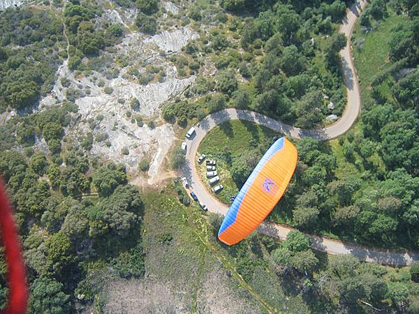
| takeoff | It is a VERY long glide to the main LZ - you must gain altitude, or you won't make it over some hills out in front. It is extremely difficult to get back to the road from there. So land on the big open BAIL OUT LZ below and in front of launch. Watch how and where locals lay their wings out, and choose which spot seems to suite you best to launch. Launch there can be very dangerous, it is a sheer rock face similar to Tollhouse. |
|---|---|
| landing | Helipad landing: Bbe aware of the surrounding trees, barb wire and telephone wires. The helipad is small, restricted and can be hot. Right next to the Road ...no hiking out ! If you overshoot, it drops down, and you'll probably end up in the trees. There is a Barb Wire fence that keeps you from coming in low. Huge open cow fields below launch: Bail out LZ is HUGE and slightly uphill and can be a very fast no wind landing. Land there and hike out. Hiking out is not bad ..as it is along a dirt road. You will have to take your boots off to cross a shallow stream. Farmers are friendly. |
| weather | |
| rules | |
| access | From Los Angeles: 5 - North, 99 - North (past Bakersfield), 65 - North to Porterville, Porterville 109 - East to Springville, LZ - end of the town right site of the road. |
| comments | On Memorial Day weekend (end of May) there is often a fly-in. Every year a lot of PG and HG are getting together to fly there. A beautiful Valley by the Sequoia park. |
| contact | |
| web | |
| tourism |
Courtesy of windy.com